White Horse Hill

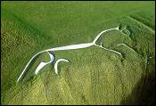
White Horse, Uffington
UFFINGTON WHITE HORSE is the 2nd largest hill figure after the Whipsnade lion and one of seven in the local area. It is the only one to face right.
The horse is dated as 1000BC - others in the area date from the late eighteenth century through to 1937
This horse was constructed by in-filling with chalk a series of trenches cut to shape into the hillside. (Others were made by turf removal only). There were theories during the 1960s that there had once been the full figure of a horse, the shape we see today being the remains.
The origin of the horse has been the subject of theories for at least 250 years. It has been variously thought to be, amongst other things, a landmark for travellers, a religious icon, and a tribal badge. The myths surrounding the horse include such notions that it leaves the hillside to feed in the Manger; it is gradually climbing up the hill; it goes to Wayland's Smithy to be shod; turning three times on the horse's eye grants your wish - (though this practice is not allowed as causes damage).
Some people also think that energy forces within the earth meet at the horse's eye where they flow out like a fountain, and that sitting on the eye enables you to absorb this energy.
The horse has survived by being regularly cleaned (scoured) by local villagers. The Lord of the Manor was obliged to provide food and entertainment for 'scourers' and this developed into the 'Pastimes'. These were huge two day events with thousands of people attending, - food and drink stalls, sideshows, musicians, were provided and games took place for which people would travel from neighbouring counties
During WW2 the horse was covered so that it could not be used as a landmark by enemy planes. It was uncovered in 1952 by W F Grimes and local labourers. Grimes was a keen archaeologist and took the opportunity to dig a small trench through the 'beak' and record the cross section. Before filling the pit a halfpenny was left at the base. It was the rediscovery of Grimes' papers which revealed that the horse was three dimensional and could be excavated.
The Oxford Archaeological Unit digs in the early 1990's confirmed that the shape and position of the horse had changed little, and that it was approximately three thousand years old.
Read more on the Mysterious Britain website. and https://en.wikipedia.org/wiki/Uffington_White_Horse
Dragon Hill, Uffington Castle and the Manger

Dragon Hill
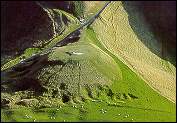
Dragon Hill is a natural hill, flattened by man, that may once have been connected to White Horse Hill. It could have been the site of a fort commanding access to the hill fort, or a religious site, where rituals of good over evil, or day over night, took place.
There are a number of myths about the hill; that it was the site of St George slaying the dragon; that the dragon's blood drained from its body and poisoned the ground so that grass will not grow on that spot; the dragon is buried under the hill; Uter Pendragon, father of King Arthur, is buried beneath the hill. The Manger is the largest and most spectacular of several dry coombs. The ripples on the western side known as "giants' steps" were created by head erosion (cutting back at source of a stream) of a series of springs. The V has been incised deeper by ice and melt water during ice age thaws.
The terraces are a remnant of medieval farming. The large population before the black death, in the 1340s, meant that all suitable land was cultivated, but farming the thin soil of the upper slopes was restricted by poor ploughs.
Mythically, the White Horse leaves the slopes of its hill once a year to feed in the manger at night.
Uffington Castle is one of a chain of hill forts along this section of the Ridgeway, - Segsbury, Rams' Hill, Uffington, Liddington, and Barbary. It is a univalate hillfort, ie of single ditch, single rampart design, with an interior area of approximately 8 acres. Originally there were two entrances, the western (remaining) one and an eastern one filled in during the Roman period. NE and SE entrances are probably Roman.
Built approximately around 500 BC, it had ramparts topped with a wooden palisade, replaced by a sarsen stone wall around 300 BC. The ditch , originally 10 ft deeper than at present, has been partly filled with stones from the wall which was pushed down during the Roman period.
The fort was only used temporarily or seasonally, and probably a meeting place, animal corral, ritual centre, or Ridgeway travellers' stop. Artefacts discovered during archaeological digs in the 1990s suggest that usage increased during the Roman period.
There is no water on the hill, although it is possible that clay lined ponds were constructed, but have all been ploughed out.
The white 4ft obelisk on the eastern outer bank of the fort is a trig point, which marks the highest point in Oxfordshire, - 858ft. It is one of 25,000 used before the advent of satellite surveying, to map the country. This trig point is one of a small number still in use by the Ordnance Survey, and is a known trig point from which GPS can be tracked. The distance between this trig point and the one at Liddington Castle formed the standard distance from which imperial Ordnance Survey maps were scaled.