Housing Developments in Faringdon since WW2
|
Some dates are guessed and some taken from the planning permission . It's not known how long after the planning permission the new houses were built and occupied.
If you can tell me anything, please do. Contact |
Thought to be 1960s
|
|
2022- none of these started in 2022
Fernham Road 25 houses South Steeds 125 Ferndale St 4 Rogers concrete 95 |
2023
14 houses Tetronics site Canada Lane Wicklesham Quarry planning for Science park sought |
|
2021
Oriel gardens, Park Road construction 500 houses, 2 phases, school (open 10/2022). Phase 2 Extra Care Home Highworth road South construction. 200 houses 2010 The Steeds 200 houses 2018 Fernham Fields 250 houses 2018 Folly Park View 2010 Southampton St 11 houses, 2019 |
2000
Volunteer Way early 2000s Wearn Road 11 houses 2003 Eastfield Court 53 sheltered flats 2003 Carey Court 6 houses 2006 Haynes Close. Coxwell Road 15 houses 2005 Dundas Court 9 flats 2002 Fernham Gate 33 houses 2003 Berry Close 10 houses 2006 25 Coxwell Road 3 houses 2007 Dove Court. 53 flats, 11 houses 2003 Goddard Court |
1990
Clocktower court 22 houses 1990s Coleshill, Catkins 109 houses 1998 Harding Close late 1990s Combes Close 6 houses 1992 Tollington Court 6 houses 1992 Greengates 14 flats and houses 1997 Ferendune 40 flats 1990 Old Police Station Coach Lane. |
1980
Tuckers Road 148 flats & houses 1988 Nursery View. 66 houses 1984 Windyridge 18 houses and flats 1980s Berners Way 30 houses1982/83 Woodview 15 houses 1988 Coxwell Gardens 28 houses 1988 Willes Close 22 houses 1987 Gloucester Mews 6 1984 Regent mews 12 flats 1984 Homeless Hostel, Glos St.1988 Elms Flats 3 flats 1986 Ash Close 13 houses 1987 Sudbury Court 4 houses 1985 Moynes Court 5 houses 1987 Oakwood 20 flats 1980 Bowes House 14 flats 1985 Coxwell Lodge care home 1988 Pulling Close 17 houses 1989 |
|
1970
Portway, Westbrook, The Lees 62 houses 1970s The Eagles 70 houses and flats 1975 Orchard Hill mid 1970s The Pines, Chestnut Ave, Maple Rd 1970s Marines Drive. 100 houses Tower View 1970s Ferendune 12 1971 Lansdowne Road 75 1971 Brackendale 1970s |
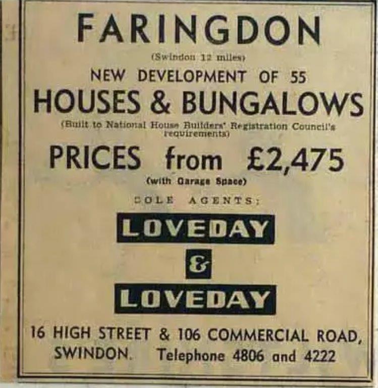
1960
Folly View Road 36 houses 1960s Westland Road 55 houses 1960 Leamington Drive 9 houses 1960. 10 houses 1956 |
1950
Pitts Estate Goodlake Ave, Bennett Road, Pye St 100 houses 1950s Untons Place 26 flats 1955 Fernham Road 10 houses 1956 Carters Crescent 1955 23 houses |
Pre ww2 and 1940s
Station Road/Park Road 1930s Marlborough Close Marlborough Gardens 1940s |
Non Housing
Tesco 2013
Carters supermarket (later Budgens) 1970s
Aldi/Waitrose/Costa 2018
BT Exchange, Marlborough St 1970s
Police Station Marlborough St 1970s
Fire Station 1974
Travelodge/ Home Bargains ( near Aldi) 2021
New Primary School. Construction 2021
Tesco 2013
Carters supermarket (later Budgens) 1970s
Aldi/Waitrose/Costa 2018
BT Exchange, Marlborough St 1970s
Police Station Marlborough St 1970s
Fire Station 1974
Travelodge/ Home Bargains ( near Aldi) 2021
New Primary School. Construction 2021
Great Faringdon can be classified as a Civil Parish. From the 1911 to the 1971 Census, it was located within Faringdon Rural District in Berkshire
etc.
The broad picture of population change can be followed from census to census, but as each census has evolved to reflect and keep up with changes in society, direct comparison does not necessarily provide a good source of information about detailed change over time. Changes in the questions asked, in the categories used to present results, and in geographical boundaries, mean that each census primarily provides a 'cross sectional' picture of the country at the time.
Elements of continuity can nevertheless be found, for example the boundaries of local government areas in England did not change substantially between 1981 and 2001, after wholesale reorganisation in 1974, as referred to above.
The census historical path back to the 1911 Census is below although note that, based on the area measurements below, it can be seen that there must have been a boundary change between 1951 and 1961.
No census was taken in 1941 because of the Second World War.
Year |
Population |
Hectares |
Source |
1911 |
3079 |
2386 |
1911 census administrative are vol 1 |
1921 |
2758 |
2386 |
County report table 3 |
1931 |
2702 |
2386 |
County report table 3 |
1941 |
No census WW2 |
||
1951 |
3207 |
2386 |
County report table 3 |
1961 |
3389 |
1435 |
County report table 3 |
1971 |
3609 |
1435 |
County report table 3 |
1981 |
4646 |
1435 |
Ward and Civil Parish monitors |
1991 |
5235 |
1432 |
Ward and Civil Parish monitors |
2001 |
6187 |
1431 |
Key Statistics Table KS01 parishes |
2011 |
7121 |
1429 |
Key Statistics Table KS101EW parishes |
2019 |
8000est |
Estimate. Boundary change to include Coxwell Road developments. Folly Park View fully occupied. In fill developments |