Faringdon through history
A Short History of Faringdon by Gerald Taylor, 2000
From 1218 through the Civil War, the coaching era, the railway and into the mid 20th century
From 1218 through the Civil War, the coaching era, the railway and into the mid 20th century

Salutation and Crowdy and Rose in 1928
|
Faringdon in 20th centuryShops and Businesses
There have been many changes in the range and numbers of shops in Faringdon over the years. You can see where shops were located on Past Businesses. You can also see a photographic record since 1980s This document 'Notes on the Buildings of Great Faringdon' was written by Gerald Taylor in 2000. Information about important buildings and housing is set in context of the growth of Faringdon. Around 1900 there were 19 inns in Faringdon. By 2006 there were 8. Take a humorous journey around Faringdon's pubs, and see photos of some closed and those remaining. Find out more on the dead pubs website. Faringdon Official Guide c 1960s p1 to p9 p10 tp p23 Faringdon in 1903 Geoffrey Williams Faringdon in 1907 Geoffrey Williams |
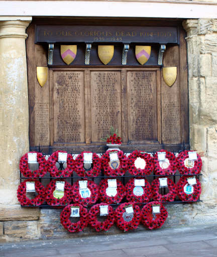
WW1 and WW2 memorial. Market Place
|
Faringdon in World War IIIn World War II the threat of a German invasion required defences inland. The German intention was to move rapidly inland and to attempt to capture the Thames bridges.
In June 1940 Faringdon was identified to be a 'Vital Point' and designated as an 'Anti-Tank Island' (a defensive strongpoint) comprising road blocks, pill boxes, fortified houses and loopholed walls. The defence system of Faringdon was part of 'Stop Line Red' which extended along the River Thames. Radcot Bridge was a major defensive feature located some 2 miles to the north on the A4095. Faringdon Folly Tower was used as a look out post by the Homeguard Find out about Faringdon's Defence Role in WW2, and WW2 memorial records for each person who died. Faringdon's War memorial As part of the Old Town Hall in the Market Square it lists the names of those who died in both World Wars. Since the early part of 21st century, new streets in Faringdon have been taken from the memorial list. Find out about the History of Faringdon War memorial in news cuttings.(2.6mb) Collated by Dr Mike Wise and WW1 and WW2 memorial records for each of those who died.
|
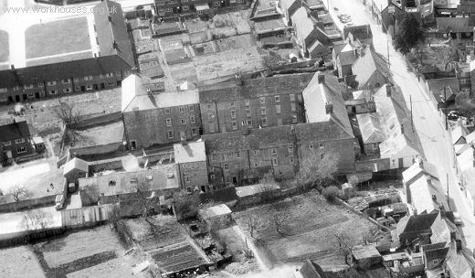
Faringdon Workhouse, Ferndale Street
|
Female School of Industry and Faringdon WorkhouseThe Female School of Industry provided pauper children with training,mostly in domestic and agricultural skills. It was in London St near the Stanford Road turn.
On the site in Ferndale Street where Brackendale sheltered accommodation now is, there used to stand the Faringdon Workhouse. Many will remember the rather grim building which stood there. In 1800 the Faringdon Poor House Committee met for the first time to discuss the prospects of ‘either hiring or purchasing a house for the maintenance and employment of the Poor’. The Committee resolved to erect a Workhouse in Ferndale Street (then called Back Street) and the six nominated Guardians of the Poor were asked to borrow £1500 for the purpose. Read more..... Faringdon Workhouse. Andrew Edgington (pdf) Faringdon Workhouse . Faringdon History Society Workhouses website Female School of Industry and the Workhouse |
|
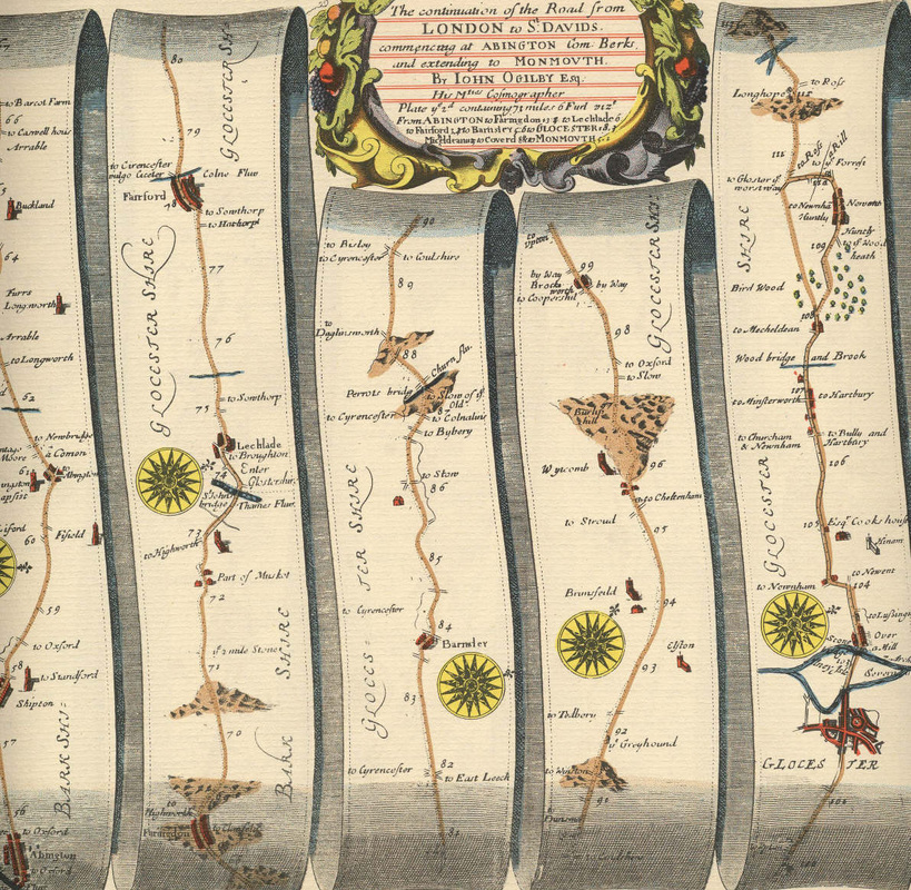
Coaching era. Mid 17th century for up to 200 yearsA north-flowing river emerging from the sponge gravels on Folly Hill cut a valley through the Golden Ridge on its way to the Thames, providing a rare crossing point and access to the Golden Ridge; so, from ancient times Faringdon has been an important crossroads.
The road from London to Cirencester, via Abingdon and Oxford, and then on to Gloucester, Bristol the West Country and South Wales crossed the road from the North of England, via Coventry and Burford, to Marlborough, Winchester and Southampton. Note that the streets in the town centre are named after the principal coach destinations.(Southampton, Marlborough, London, Gloucester) From 1635 a courier service ran between London and Bath and the Crown was where the post-boy riders changed their horses; but because of their drinking habits, they were appallingly unreliable. By 1773 Faringdon was connected by a turnpike to London and Gloucester, and by 1752 to Wantage and Wallingford. By the 1780s stagecoaches were used for delivering mail, which was more reliable than the post-boys and Faringdon is where the gummed envelope was invented! ( no proof of this found) By 1813 coaches to London from the West Country came through on Tuesdays, Thursdays and Saturdays and by 1840 coaches were coming through twice day. Horses needed to be changed, which explains the large number of mews and stabling around the town and the coaching inns for the travellers; Faringdon was a town known for its hospitality, ales and good food. Map kindly provided by John Gillman Unfortunately Faringdon is at the bottom of the page. Note that Buscot seems to be listed as Musket. |
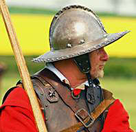
Pikeman. Civil War 1645
Seal
|
Civil War 1642-1651At the beginning of the Civil War between the forces of Parliament and King Charles, the King had to base himself on Oxford, surrounding the city with a circle of fortified towns which included Faringdon. The market town of Faringdon was an important five way road junction with Radcot Bridge over the Thames to the north, the main London coach road to the east via Abingdon, Southampton Street to the south and then going west the main London coach roads to Gloucester via Lechlade and to St Annes via Highworth.
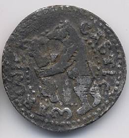
Blessed with a plentiful supply of clean running spring water throughout the year, Faringdon was a vibrant market town, strategically vital for the western defences for the King at Oxford. Cromwell quartered himself on the slopes of Folly Hill on 29th April 1645. He called upon the Royalist's Commander Colonel Lisle, who had a strong defended position at Faringdon House and All Saints Church, to surrender, but to no avail. The muster roles for Rawdon's Regiment defending Faringdon in 1646 still exist. The roles show that 48% of Rawdon's combat strength in Faringdon were men, 10% women in support and 42% "Posemen". A Poseman was a woman dressed as a soldier and normally used in the musket block as a sniper. The Posemen in Rawdon's were armed with long 28 bore muskets which were accurate to about 120 yards, compared with the men's 10 bore muskets which fired a heavier ball, but only accurately to about 40 yards. Rawdon appreciated that for siege defence he needed long range snipers to defend the ramparts, recruiting a large number of female Posemen. So Faringdon was defended actually by a force made up of 52% women - the deadly majority who saw off Cromwell with heavy casualties. The musket ball on display in All Saints' Church is of 28 bore calibre, so would have been fired by a female Poseman. More information and pictures Gift from King John to build a Cistercian Abbey 1202
The Cistercian Abbey was in fact built at Beaulieu. The monks retained a cell here (at Wyke. North of Faringdon between the Radcot Road and Grove Wood) and they owned the Great Barn at Great Coxwell. |
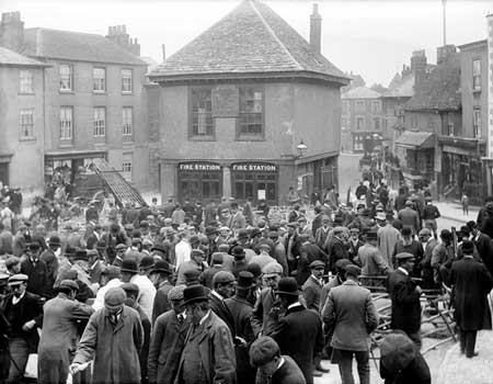
Market Day 1895
|
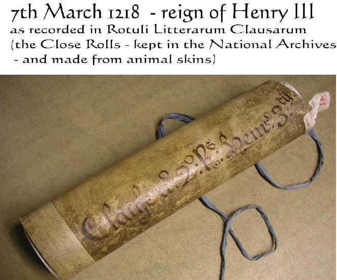
Market Charter for Faringdon 12187th March 1218. Reign of Henry III
Ferendon Market: The Shire of Berkshire is ordered to hold a market in Ferendun on Mondays so long as this does not cause nuisance to surrounding markets. 18th February 1313. Reign of Edward II Market changes from Mondays to Tuesdays More information and pictures (pdf) Extract from http://www.history.ac.uk/cmh/gaz/gazweb2.html (Samantha Letters, Online Gazetteer of Markets and Fairs in England and Wales to 1516) FARINGDON 4288 1957. Borough 1225 (BF, supplement, p. 61). 1334 Subsidy £155.97. Market town c.1600 (Everitt, p. 473). See also VCH Berkshire, iv, p. 492. M (Prescriptive: borough) recorded 7 Mar 1218, mercatum. On 7 Mar 1218, K Hen III ordered the sh of Berkshire to ensure that the market was henceforth held on Mon (RLC, i, p. 354). This was probably an order to change the day of an existing market; although the previous day of the market was not stated, it was very likely Sun. On 18 Feb 1313, it was stated that whereas the A and M of Beaulieu had from a long time past had by grant of the king’s predecessors a Mon market at their manor, the A, M and burgesses of the town had petitioned that the day be changed to Tues, which the king granted in lieu (CChR, 1300–26, p. 203). Another licence for a change to Tues was obtained in 1594 (VCH Berkshire, iv, p. 492). F (Letter Close) vf, Luke the Evangelist (18 Oct); feria gr 26 Jan 1222, by K Hen III to A of Beaulieu. To be held at the manor until the king came of age (RLC, i, p. 486). Granted by K Hen III to the A and M of Beaulieu on 20 Sept 1227 (CChR, 1226–57, p. 60). F (Prescriptive) v, Trinity Sunday (Easter dep); recorded 1260 (VCH Berkshire, iv, p. 492). |
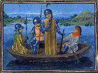
Robert de Vere fleeing Radcot Bridge, 1387
|
King Stephen and Empress Matilda war 1144
Faringdon was heavily fought over in 1144 when King Stephen attacked Queen Matilda's fort on Folly Hill, capturing it after a 3 day battle. There were cavalry skirmishes later during the Wars of the Roses at Radcot Bridge, 1387, with Faringdon opting for the Red Rose side - look in the Crown Hotel's downstairs bar for the red rosed crown in the window, glass which by definition predates the Battle of Bosworth in 1485, when the Crown merged red with white. Displayed in a bar below street level this surely signifies one of current Oxfordshire's oldest political statements - Red Here, go White Somewhere Else! About Faringdon Castle |
All Saints' Church
|
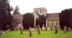
All Saints' Church 12th Century
Like all English medieval churches, All Saints was built for Roman Catholic worship. After the Reformation most churches were altered to new requirements, and have been further changed by desecration, extension, rebuilding and internal alteration, demolition or conversion to other uses. All Saints is no exception More information on: http://www.faringdon.org/all-saints-church.html |
Domesday Book
|
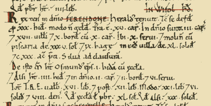
Great Faringdon in the Domesday Book 1086
See more on http://opendomesday.org/place/SU2895/great-faringdon/ |